Navigation
DISCLAIMER:
The nowcast/forecast system and other analyses/data are research
products under development. No warranty is made, expressed or implied,
regarding accuracy, or regarding the suitability for any particular application. All rights reserved University of South Florida, Ocean Circulation Lab.
Copyright University of South Florida 2010
Sargassum Tracking for the Gulf of America, the Straits & East Coast of Florida
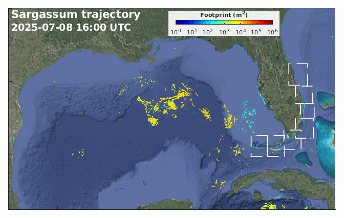
Click dashed-line boxes to zoom in sub-regions along the south and east Florida coast: from south to north, the Dry Tortugas, Lower Keys, Florida Bay, Biscane Bay, Gold Coast, South Indian River Lagoon and North Indian River Lagoon regions.
A Sargassum short-term trajectory forecast product has been developed by combining satellite imagery with numerical models. Once a bloom is detected through remote sensing, its location and time information are used to initialize a Lagrangian trajectory model, and the patch is tracked by the simulated ocean currents. Color-coded is the percentage of Sargassum coverage within each satellite pixel. Two types of satellite imagery are available, one with a spatial resolution of 60 m, and the other 1 km. The Sargassum patches shown on the map are in proportion to their actual sizes.
This forecast system includes three numerical models: the West Florida Coastal Ocean Model (WFCOM), the East Florida Coastal Ocean Model (EFCOM), and the Global Hybrid Coordinate Ocean Model (HYCOM). The bloom patches in coastal areas are tracked by WFCOM or EFCOM, and those outside the coastal ocean model domains are tracked by HYCOM. The modeling system is updated automatically every day, providing a 1-day hindcast and 3.5-day forecast of the trajectories as shown in the above movie.
Both WFCOM and EFCOM nowcast/forecast systems are developed by the Ocean Circulation Lab (OCL), and the Sargassum satellite product is developed by the Optical Oceanography Laboratory (OOL), both in College of Marine Science, University of South Florida.
Acknowledgements
The Sargassum tracking product is supported by the NOAA NCCOS MERHAB program. The ocean circulation modeling efforts benefit from several projects funded by NOAA COMIT, IOOS/SECOORA, NCCOS ECOHAB, State of Florida through FWC/FWRI, Florida DEP, and Florida Flood Hub.
Sargassum Tracking
- Sargassum Tracking for the Gulf of America, the Straits & East Coast of Florida
- USF/CMS Ocean Circulation Lab (OCL)
- West Florida Cosatal Ocean Model (WFCOM)
- Tampa Bay Cosatal Ocean Model (TBCOM)
- Global Hybrid Coordinate Ocean Model (HYCOM)
- USF/CMS Optical Oceanography Lab (USF COOL)
- USF College od Marine Science (USF/CMS)
- University of South Florida (USF)